|
The passuk in Ezra (6:4) says that when Koresh (and later, Daryavesh) gave the Yidden permission to build the second Beis Hamikdash, he told them to make the walls of "נִדְבָּכִין דִּי־אֶבֶן גְּלָל תְּלָתָא וְנִדְבָּךְ דִּי־אָע חֲדַת-three rows of marble stone and one row one wood". The Gemara (Rosh Hashanah 4a) says that the reason he said this was so that if the Yidden rebelled, he can easily burn the Beis Hamikdash, as it has wood in it which makes it flammable. From this we see that Daryavesh, even though he was good in the beginning, soured out. The Gemara asks, that Shlomo Hamelech did the same thing, as the passuk says (melachim I 6:36 in regard to the Azarah, and 7:12 in regard to the Ulam). The Gemara answers that there were three differences between how Shlomo Hamelech built it and how Daryavesh commanded to build it. First of all, Shlomo put his row of wood on top of the three rows of stone, so that even if there was a fire, the bottom of the wall would still be standing, while Daryavesh said to put the wood on the bottom, under the three rows of stone, so that if you burn it, the whole wall collapses. Secondly, Shlomo sunk the wood into the wall, with the stones protruding more than the wood, while Daryavesh made it even. Thirdly, Shlomo covered the wood with plaster, to prevent it from catching on fire, while Daryavesh didn't.
1 Comment
The Medrash in various places (Sh'mos Rabba 2:2, Bamidbar Rabba 11:2) says that the shechinah even today rests on the western wall (the Kosel), and it therefor will never be destroyed. This is also brought down in Shir Hashirim Rabba, although the Medrash there is slightly different, and says the following:
הִנֵּה זֶה עוֹמֵד אַחַר כָּתְלֵנוּ, אַחַר כֹּתֶל מַעֲרָבִי שֶׁל בֵּית הַמִּקְדָּשׁ, לָמָּה שֶׁנִּשְׁבַּע לוֹ הַקָּדוֹשׁ בָּרוּךְ הוּא שֶׁאֵינוֹ חָרֵב לְעוֹלָם, וְשַׁעַר הַכֹּהֵן וְשַׁעַר חוּלְדָה לֹא חָרְבוּ לְעוֹלָם עַד שֶׁיְחַדְּשֵׁם הַקָּדוֹשׁ בָּרוּךְ הוּא. מַשְׁגִּיחַ מִן הַחַנוֹת, זוֹ זְכוּת אָבוֹת. מֵצִיץ מִן הַחֲרַכִּים, זוֹ זְכוּת אִמָּהוֹת. “Behold, he is standing behind our wall,” behind the Western Wall of the Temple. Why? Because the Holy One blessed be He took an oath that it will never be destroyed. and the Kohen's Gate (Sha'ar Hakohen) and Chulda Gate (Sha'ar Chuldah) will never be destroyed until the Holy One blessed be He refurbishes them. Now, what are these two gates that will never be destroyed? Seemingly, the Chuldah gate is easy to identify, as the Mishnah (Middos 1:3) mentions the Chuldah gates in the southern wall of the Har Habayis. However, this raises a question, as that Mishnah is referring to the gates of the square 500 amah Har Habayis, of which none of the walls or gates have survived. To answer this, we must say that both the Kohen's gate and the Chuldah gate are referring to gates of the expanded Har Habayis, part of which still stands (which is why the Medrash says the Chuldah Gate, singular, as it is not referring to the two Chuldah gates of the Mishnah). But there many gates from the times of the Beis Hamikdash whose remains are still extant in these outer walls, which gates is the Medrash referring to? The Passuk in Ezra (6:3) says that when Koresh gave the Yidden permission to build the second Beis Hamikdash, he told them to make it 60 amos wide and 60 amos tall. The question arises, however, that the Mishnah (Middos 4:6) writes that the Heichal was 100 amos wide, long, and tall. The Rambam (Hilchos Beis Habechirah 4:3) writes that this talking about the Heichal built by the Bnei Hagolah, the Yidden who returned from the exile to Bavel and built the second Beis Hamikdash. (This is as opposed to the First Beis Hamikdash, or Hurdus's renovated second Beis Hamikdash, which were both 120 amos tall, as we will soon discuss.)
The simplest answer to this question would seem to be that Koresh did not know exactly how big it was supposed to be, so he said sixty, but he really did not care, and let them make it one hundred. However, the Medrash says (Esther Rabba 1:5) that Hashem was angry at Koresh for dividing the Beis Hamikdash in half, as during the first Beis Hamikdash it was 120 amos tall, and Koresh said to make it sixty. From this it sounds like Koresh says sixty specifically; and did not let more. One can say that when Daryavesh became king and gave the Yidden permission to continue building the Beis Hamikdash (after the construction was halted by Koresh and Achashverosh because of libels by the antisemites), he let them make it one hundred amos tall, however there is another Medrash (Bamidbar Rabba 14:18) which says that the second Beis Hamikdash was actually built sixty by sixty amos. [see Eitz Yosef on the Medrash there, who raises this contradiction between this and the Mishnah in Middos, but does not answer it.] In the first Beis Hamikdash, the tables in the Beis Hamitbachayim were made of silver;1 in the second Beis Hamikdash they were made of marble.2 (However, even in the first Beis Hamikdash there were marble tables in other places,3 such as the table next to the ramp where they put the meat of the Korbanos until they were offered.4)
1 Divrei Hayamim I 28:16. The Passuk just mentions silver tables, without explaining what they were used for, the Mefarshim (Mefaresh, Radak, and Medrash Divrey Hayamim from R' Shmuel Masnos) explain based off of Yechezkel (40:39-41) where he mentions stone tables that the were used while skinning and cutting up the Korbanos, and say that these are the tables that we are referring to here as well (these tables of yechezkel correspond to the eight tables in the Beis Hamibachayim, see Rashi Yoma 16b). The question arises why do the Mefarshim explain like this, and we have to say that the First Beis Hamikdash is different than both the second and the third, as in both of them these tables were made of stone, why don't they explain the Passuk as referring to the silver tables known to be in the second Beis Hamikdash, like the table next to the ramp where the Keilim were stored (Shekalim 6:4), or the table in the Ulam where the Lechem Hapanim was placed on before bringing it in to the Heichal, which according to some opinions was made of silver (see Tosafos to Menachos 99b)? This is especially problematic as this is not just a detail you can say they just changed, and the material of the tables were not part of the instructions handed down; we cannot say this, as the Passuk in Divrei Hayamim that mentions the silver tables is describing the details of the Beis Hamikdash that David told Shlomo, when he gave him the scroll of the Megillas Hamikdash! One answer we can give is that the mefarshim would rather say that the Passuk in Divrei Hayamim is relying on a different Passuk in Tanach, rather than on something that is not mentioned in Tanach at all. Another (more probable) answer is that they want to explain the Passuk according to the opinion that the table in the Ulam was marble, and there was therefore only one silver table in the second Beis Hamikdash, while the Passuk mentions silver tables, more than one. From the above it comes out that this is one of the changes that they changed in the second Beis Hamikdash to be like the third. There is also a reason for this change, as marble does not heat up, while metal does, and makes the meat spoil faster (See Yerushalmi Shekalim 6:3 and Bavli Tamid 31b). 2 Middos 3:5 3 See Mefaresh to Divrei Hayamim I 29:2 4 Shekalim 6:4  The Gemara in Yoma (21b, 39b) says the following:
אָמַר רַב זוּטְרָא בַּר טוֹבִיָּה: לָמָּה נִקְרָא שְׁמוֹ יַעַר, דִּכְתִיב: ״בֵּית יַעַר הַלְּבָנוֹן״, לוֹמַר לָךְ: מָה יַעַר מְלַבְלֵב — אַף בֵּית הַמִּקְדָּשׁ מְלַבְלֵב. דְּאָמַר רַב הוֹשַׁעְיָא: בְּשָׁעָה שֶׁבָּנָה שְׁלֹמֹה בֵּית הַמִּקְדָּשׁ, נָטַע בּוֹ כׇּל מִינֵי מְגָדִים שֶׁל זָהָב, וְהָיוּ מוֹצִיאִין פֵּירוֹת בִּזְמַנֵּיהֶן. וְכֵיוָן שֶׁהָרוּחַ מְנַשֶּׁבֶת בָּהֶן הָיוּ נוֹשְׁרִין פֵּירוֹתֵיהֶן, שֶׁנֶּאֱמַר: ״יִרְעַשׁ כַּלְּבָנוֹן פִּרְיוֹ״, וּמֵהֶן הָיְתָה פַּרְנָסָה לַכְּהוּנָּה. וְכֵיוָן שֶׁנִּכְנְסוּ גּוֹיִם לַהֵיכָל יָבְשׁוּ, שֶׁנֶּאֱמַר: ״וּפֶרַח לְבָנוֹן אוּמְלָל״. וְעָתִיד הַקָּדוֹשׁ בָּרוּךְ הוּא לְהַחְזִירָהּ לָנוּ, שֶׁנֶּאֱמַר: ״פָּרוֹחַ תִּפְרַח וְתָגֵל אַף גִּילַת וְרַנֵּן כְּבוֹד הַלְּבָנוֹן נִתַּן לָהּ״. Rav Zutra bar Toviya said: Why is the Temple called: Forest, as it is written: “The house of the forest of Lebanon” (Melachim I 10:17)? To tell you: Just as a forest blooms, so too the Temple blooms. As Rav Hoshaya said: When Solomon built the Temple, he planted in it all kinds of sweet fruit trees made of gold, and miraculously these brought forth fruit in their season. And when the wind blew upon them, their fruit would fall off, as it is stated: “May his fruits rustle like Lebanon” (Tehillim 72:16). And through selling these golden fruits to the public, there was a source of income for the priesthood. But once the gentile nations entered the Sanctuary the golden trees withered, as it states “The flower of Lebanon withers” (Nachum 1:4). And in the future hour of redemption, the Holy One, Blessed be He, will restore them to us as it is stated: “It will blossom and will rejoice, even with joy and song, the glory of Lebanon will be given to it” (Yeshayahu 35:2). The north wall of the expanded Har Habayis was mostly destroyed, and virtually no remains can be seen above ground, besides for a few stones in the northeast and northwest corners. (The Kaftor Vaferach already observed this fact, as he writes (chapter 6) that the northern wall is destroyed, as opposed to the other walls, where he found remains of all the gates mentioned in the Mishnah, see my earlier post about this Kaftor Vaferach.) However, it seems that there are still remains of this wall underground, as the present north wall of the Har Habayis is on the same line as we would make the Herodian north wall be, based on the remains at both corners. 
On the north side of the Har Habayis, in the eastern part, there is a large pool, called by the Arabs Birket Isra'in, a corruption of Birket Beni Israil, pool of the sons of Yisroel. It is first mentioned by this name by Muqadassi, an Arab geographer, in the tenth century. There are different opinions about its date, with some dating to Herodian times, and some dating it to later times, like when the Romans rebuilt Yerushalayim as a pagan city, called aelia capitolina, during the times of Hadrian yemach shemo. Towards the end of the 19th century, the pool was being used as a garbage dump, as well as a vegetable garden. In 1934 the pool was filled in because its condition posed a threat to public health. In 1981 a small square equipped with benches was constructed on part of the covered pool. Today the area is known as el-Ghazali Square, and is used as a parking lot, as well as a collection point for garbage, before it is dumped outside the city. Some small shops also exist at the site.
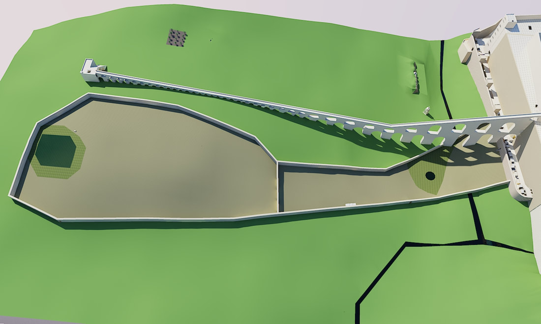
Above the ground, the northeast corner of the (expanded) Har Habayis can be clearly seen, and to the north of it is the more modern eastern city wall of Yerushalayim. However, underground the Har Habayis wall does not end at this point, but runs further, for another 38.4 meters (126 feet). Warren writes the following about this (Survey of Western Palestine, Jerusalem, pp 129-130): Gallery along east wall of Sanctuary, Commenced 5th June,1869. From a point (P) 18 feet south of the north-east angle, a gallery was driven along the wall (level 2,363 feet 3 inches [720.31 m]) to north, past where the straight joint between the Castle of Antonia and city wall should occur; but no straight joint was found to exist. The wall runs on without a break of any kind, and there is no projection... To a distance of 65 feet (19.81 m) the stones were all like those at the Wailing Place, but beyond this to 75 feet (22.86 m) they had rough projecting faces (projections about 6 to 10 inches [15-25 cm]) with well-cut marginal drafts.  The northern part of the eastern wall of Har Habayis, from the northern joint to the northeast corner of the Har Habayis, a distance of around 121 meters (397 feet) is from Hurdus's expansion. This wall crossed over the Bezesa valley and continued onto the hill north of Har Hamoriah. By the northeast corner, there is a tower that was (mistakenly) called "The Tower of Antonia" (The Antonia fortress, mentioned by Josephus, was actually by the northwest corner of Har Habayis).  The Parah Adumah was burned on top of Har Hamishchah, which is Har Hazeisim, the Mount of Olives. (The ashes of the Parah Adumah-red heifer were used to purify people from Tumas Meis.) This place was located directly to the east of the Beis Hamikdash, as learned from the Passuk (Bamidbar 19:4) "Elazar the kohen shall take some of its blood with his finger and sprinkle it directly towards (אל נוכח) the face of the Tent of Meeting seven times". From the words directly towards (אל נוכח) we learn that number one, he sprinkled the blood towards the entrance of the Kodesh Hakodoshim, and number two, that the location he was in must be directly opposite the Kodesh Hakodoshim. (The face of a building is the door, although from the fact that the passuk does not just simply say door, we learn that over here it also means the most important part of the Heichal, the Kodesh Hakodoshim. In order to see the entrance to the Kodesh Hakodoshim, however, you had to look through the door of the Kodesh. [Tosafos Chadashim, Parah 3:9])  Leading from Sha'ar Shushan, in the eastern wall of the Har Habayis, there was a long Kevesh-כבש ("bridge") that led to the place where they burned the Parah Adumah, on Har Hazeisim. (The ashes of the Parah Adumah-red heifer were used to purify people from Tumas Meis.) This place was located directly to the east of the Beis Hamikdash, as learned from the Passuk (Bamidbar 19:4) "Elazar the kohen shall take some of its blood with his finger and sprinkle it directly towards the Tent of Meeting seven times.  Josephus (Wars 5:4:2) writes amount the east wall of Yerushalayim, that at its end, "it was joined to the eastern stoa of the temple". Some (R' Yehosef Shwartz, in Tevu'os Ha'aretz chapter 7, Michael Avi-Yonah, in his famous model; the Holyland model, and others,) have understood this to mean that it joined the southeast corner of the Har Habayis, and the east wall of Har Habayis was also part of the east wall of the city, like it is today. However, this cannot be, as Rashi (סוכה נא ע"א ד"ה שלא היתה מאירה מאור בית השואיבה) seems to imply that (at least part) of Yerushalayim was to the east of the Har Habayis. Furthermore, the Gemarah (Shavuos 16a) talks about two areas on Har Hazeisim, which is located east of Yerushalayim, that were added to Yerushalayim.  The Eastern Wall of the Har Habayis, part 3 (the gates in the middle of the eastern wall)10/28/2022 The southeast corner of the (expanded) Har Habayis is built on the lowest point of the bedrock, so in order to help stabilize it, the lower rows of stone are set back from the ones under them more than in the other walls, they are set back between 7.6-10.1 cm (3-4 in), and in one case 15.2 cm (6 in). Higher up (around seven rows under the master course), however, they are set back very little, only a quarter or a third of an inch (around 7 mm). On some of the lowest stones of this corner there are letters and symbols on the stones, either painted with red paint or engraved. The margins of some of these lower stones are very irregular, with some having huge margins on one side, and very small or no margins on the other, it seems that they used unperfect stones for here, since they were below street level, and would never be seen anyway. When the stones for the Har Habayis were quarried, the masons left small square projections of about 12 cm (4 in), on either side of the stone. These projections had ropes placed around them, and were used to lift and transport the stones. When the stones were put into the Har Habayis walls, these projections were usually cut off, however sometimes they were left, and you can still see stones in the southern edge of the eastern wall which have these projections. 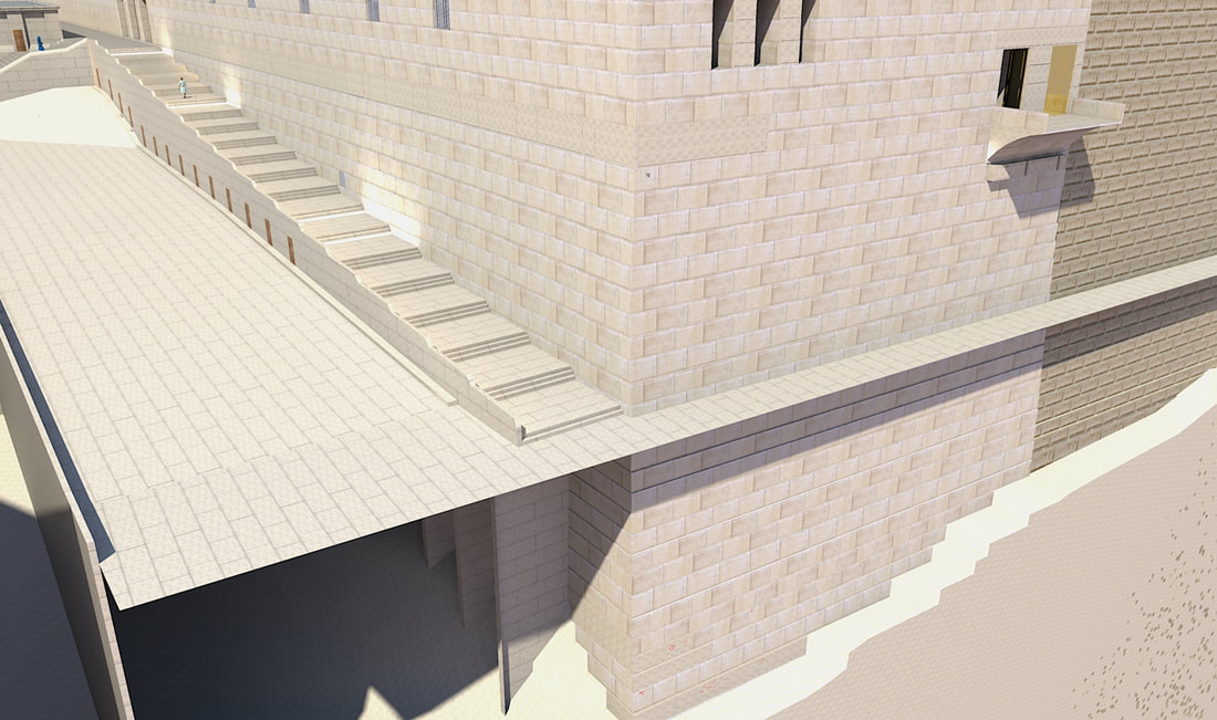 The eastern wall of the Har Habayis is 466 meters (1530 feet) long. This wall is not exactly on the north-south axis, rather it is on an angle of 6 degrees to the north. The southern part of this wall is at an angle of around 93 degrees compared to the southern wall of Har Habayis, but at 73.2 meters (240 feet) away from this corner, the wall turns slightly to the east, so at a point 198.12 meters (650 feet) from the south-east corner, the wall is 2.43 meters (8 feet) to the east of a line in production of the first 73.2 meters (240 feet).  In the southeastern corner of the expanded Har Habayis, there was a tower, the remains of which can be seen in the eastern wall. This made a nice visual balance to the eastern wall of the Har Habayis, as it had towers on both ends. 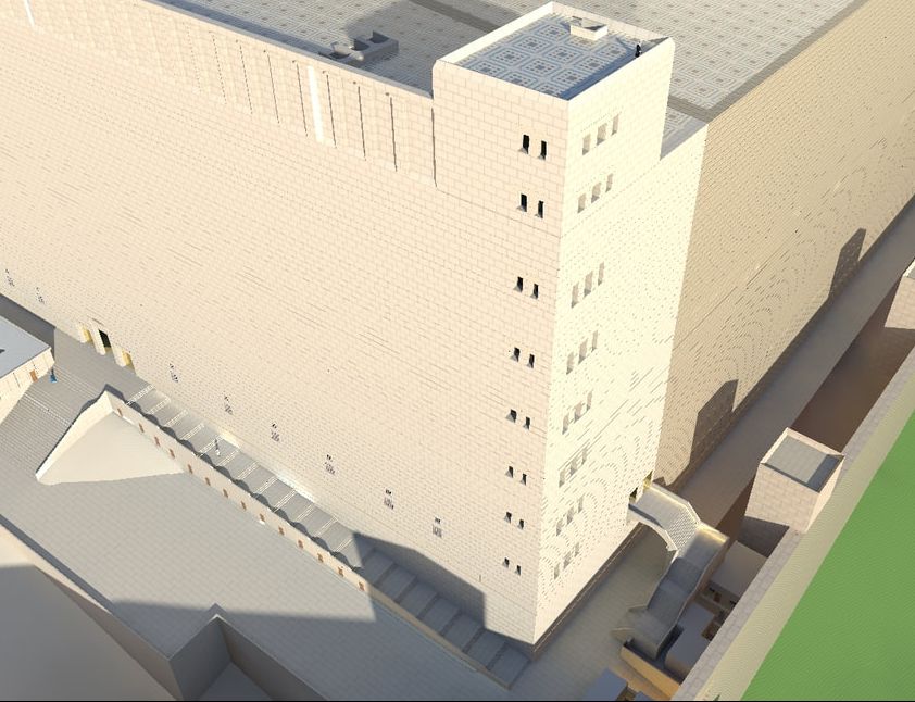 When Hurdus expanded the Har Habayis, he made his expansion on one flat level. However, the original mountain slopes down, so they had to build vaulted chambers, as well as fills of earth and other stuff, to support the Har Habayis surface. Although most of these vaults were destroyed during the Churban, the southeastern vaults were later rebuilt, and support the southeastern part of the current plaza. This vaulted area is known as Shlomo's stables. The original vaults were probably used as storage rooms; and had windows to let in light. Near the triple gate, a window frame was found, this frame had grooves for metal bars, as well as holes for the hinges of the shutters to open and close it. 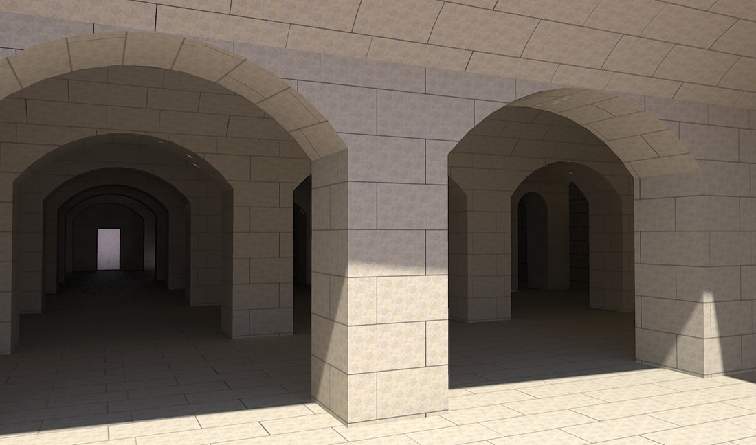 As mentioned in a previous post, running along the southern wall was a stepped walkway, 6.4 m (21 ft) wide. This walkway was built on top of rooms with vaulted roofs, these rooms most probably were stores. When the Romans destroyed Yerushalayim, they filled these stores up with wood, and lit them on fire. (The burning of this area of Yerushalayim is mentioned by Josephus, Wars 6:6:3.) The Har Habayis is mostly built from limestone, which crumbles and turns into powder when exposed to very hot temperatures (This is how lime (סיד) is made). Before these stores and the walkway totally collapsed from the heat, the fire left a burnt imprint on the Har Habayis wall, which was the back wall of these rooms, in the shape of the interior of these stores. These burnt marks have enabled us to figure out how the stores looked. (When the stones are examined closely, you can see that a semicircular line was scratched into the wall to help the builders build these vaults correctly.) 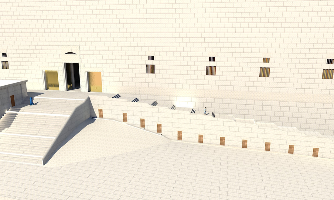 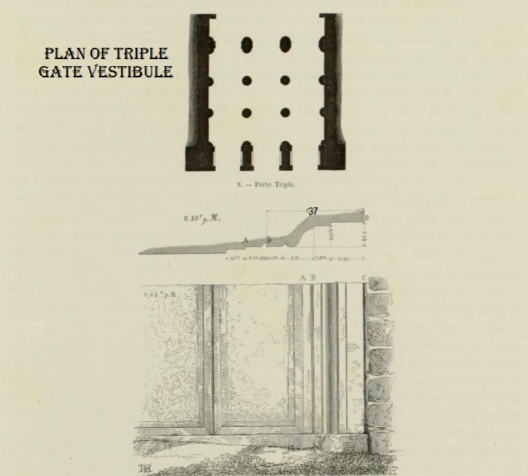 De Vogue's drawing of the molding on the remaining stone De Vogue's drawing of the molding on the remaining stone 65.6 meters (215 feet) to the east of the double gate is the triple gate (sometimes called the eastern Chuldah gate). It is 15.5 meter (51 feet) wide; and is made up of three 4-meter (13-feet) wide arched doors, separated by two 1.8-meter (6-feet) wide piers. The lowest stone of the western gate jamb, which is part of the master course, has a decorative molding on it. This stone is the only surviving stone of the original Herodian gate that stood here, the rest of the gate is from a later period, most probably from the Umayyad period. During the Crusader period, when they turned this part of the wall into the city wall (as it is today), the crusaders blocked up this doorway. This stone is 1.22 meter (4 feet) long, of which 76.5 centimeters (30 inches) on the left are dressed like regular Herodian stones, and the remaining 45.5 cm (18 in) on the right have the molding. The first 8 centimeters (3 inches) of the molding are a flat band to distinguish between the rest of the stone and the molding. 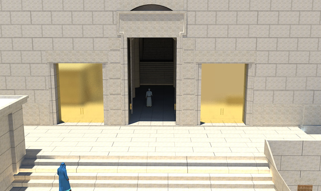 |
Website updatesI have added a new lego model of the Third Beis Hamikdash, with pictures and a video in the lego gallery. Categories
All
Archives
February 2024
AuthorMy name is Mendel Lewis. Hashem said to Yechezkel, "Its reading in the Torah is as great as its building. Go and say it to them, and they will occupy themselves to read the form of it in the Torah. And in reward for its reading, that they occupy themselves to read about it, I count it for them as if they were occupied with the building of it. (Tanchuma tzav 14) |
- Beis Hamikdash posts
-
sources
- Mishnayos Middos >
- Gemarah
- Rambam >
- Rishonim
- Sha'alos Uteshuvos HaRaDVaZ
- Shiltey Hagibborim
- Ma'aseh Choshev
- Chanukas Habayis (both) and biur Maharam Kazis on middos
- diagrams >
- Tavnis Heichal
- Be'er Hagolah
- Binyan Ariel
- Shevet Yehudah
- other
- Braisa D'Meleches Hamishkan
- Third Beis Hamikdash sefarim
- from Josephus-יוסיפון >
- קובץ מעלין בקדש
- Kuntres Klei Hamikdash
- Gallery
- videos
- 1st Beis Hamikdash
- 3rd Beis Hamikdash
- virtual walkthroughs
- 3d models
- Lego Gallery
- diagram of Mizbeach
- contact
 RSS Feed
Proudly powered by Weebly